This post by Benvenuto Triolo is part of Spacing‘s partnership with the Toronto Cycling Think and Do Tank at the University of Toronto. Find out more about the think tank, and the series, here.
Planning safe, fast, and fun routes to ride on is important, especially for novice riders such as me. Besides riding with a friend, making sure you are on good cycling roads is the best way to ease any anxiety about riding in a large city such as Toronto. Like most major cities, Toronto has a large variety of road types – from congested roads with potholes aplenty to quiet residential roads with hardly a car to be seen. I’d like to share with you what I’ve learned in my first few weeks of cycling that can make any beginner’s cycling trips much more enjoyable.
There are generally two types of routes your bike can take you on: recreational outings and commutes around the city. However, with the complexity of large cities and the variety of ways people decide to use city roads, bicycle routes come in many different shapes and sizes and are often used for purposes outside their original intentions. Residential streets, off-road trails, and cycle tracks put distance between cyclists and cars and are good choices for new riders. Recreational routes are generally more approachable for new cyclists and are a great way to build confidence on a bike before riding beside cars. There are a great number of paths completely separated from cars in most urban cities and it feels safe from the get go. For longer commutes, new cyclists might choose to take a more roundabout route through recreational paths they are more comfortable with. Even the most direct routes can include short cuts through parks or under expressways. Besides helping you feel safe, cycling on these trails can be great for exercise and can quickly take you from the urban centre to fantastic scenery. In less than an hour on my bike, I am able to meander from the top of University of Toronto campus to the beach or the famous Leslie Spit (my favourite place to bike to in Toronto, see photo above). Whether you are going to the beach, the waterfront, or the Leslie Spit, there are great trails available that make the ride relaxing and enjoyable. The Lower Don River trail is a long, connected bicycle route that runs north-south and is hidden underneath the city. Once at the waterfront, the Lakeshore Bike Route offers a wide and separated east-west path for cyclists to speed along. From there, you can escape the city by entering either Ashbridge’s Bay or the Leslie Spit, two bike trails where cars do not exist and one can enjoy leisurely rides.
Although recreational paths are more relaxing and can bring cyclists to entirely new places that were unreachable without a bicycle, they are not (in most cities), entirely practical for commuting to work, school, or the grocery store. Mostly they need to be combined with on-street routes and frequently only on-street routes are practical for reaching destinations.
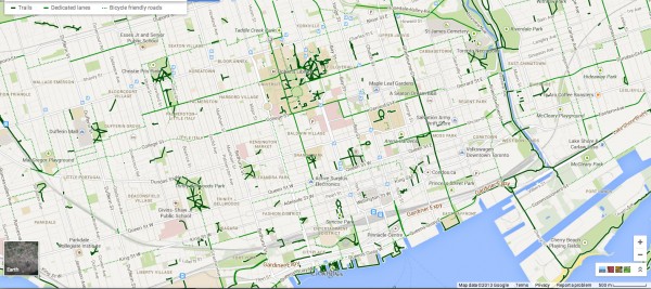
For beginner cyclists such as myself, Google Maps is a valuable tool in planning routes. It provides suggestions for accessible, reliable, and safe cycling routes which outline separated cycling trails, dedicated bike lanes, and bike-friendly streets. The software giant also updated their mobile app to include bike maps for iPhone and Android users, an awesome tool for commuting cyclists. By simply hitting the ‘Bicycling’ tab in Google Maps, you can see a great overview of any city’s cycling roads (Toronto cycling map shown below). The cycling people at the City of Toronto publish an amazing map that is really useful if you get a hard copy (the online version is a bit choppy to read). I encourage you to familiarize yourself with your city’s cycling roads and, if you’re new, start with routes with the best cycling infrastructure. Not surprisingly, streets with good cycling infrastructure are perceived as safer, which is important to encourage new cyclists and act as a stepping-stone to cycling on most streets. While good cycling infrastructure is important for safety, another key role of infrastructure is its ability to attract new cyclists. Since more cyclists equals safer cycling, this attraction acts as a positive feedback mechanism.
Triolo blog map

(Click on the map for a larger view)
While the Google cycling map is a great step in the right direction for cyclists, it does not always provide the best cycling routes for everyone. Personally, I don’t mind going a few minutes out of my way to get on a street I am more comfortable with (i.e., roads that are relatively flat, have separated lanes, smooth asphalt, or no on-street parking). A lot of this part of cycling route planning is up to your personal preference and I would recommend experimenting with multiple routes to see which meet your own needs. If you’re new like me, give yourself some extra time for travel and find the routes that help you enjoy your commute. The time-saving bicycling offers will come with experience.


